What a Topographic Survey Tells You About Your Property
Roanoke is a great place to own land. The Blue Ridge Mountains surround the valley, the ground rolls up and down, and no two properties look the same. But that same landscape that makes the area beautiful also makes building on it tricky.
Before anyone starts building, pouring a foundation, or moving dirt, there is one document that builders and engineers always ask for first: the topographic survey.
What Is a Topographic Survey?
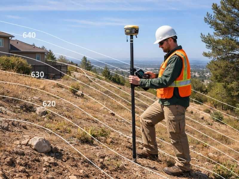
A topographic survey is a detailed map of a property. It shows the hills, slopes, drainage paths, trees, and how the ground rises and falls across the land.
A boundary survey only shows where your property ends and your neighbor’s begins. A topographic survey goes further. It shows what the land looks like on the inside, where water flows, where the ground gets steep, where trees and buildings sit, and how the whole property sits in relation to everything around it.
The finished product is a contour map. This is a drawing that uses lines to show changes in height across the property. Lines close together mean a steep slope. Lines far apart mean the ground is mostly flat.
How Is It Different From a Boundary Survey?
This is one of the most common questions people ask, and it deserves a simple answer.
A boundary survey answers the question: “Where is my property?”
A topographic survey answers a different question: “What does my property actually look like?”
One shows your legal lines. The other shows your land’s shape, slopes, and drainage. Many building projects need both, not just one.
What Does a Topographic Survey Show?
A licensed surveyor takes measurements across the whole property to build an accurate picture of the land. The finished survey usually shows:
Natural features: Streams, ponds, hills, rock formations, and large trees.
Man-made features: Buildings, fences, driveways, walls, utility lines, and drainage systems already on the property.
Elevation and contour lines: The exact height of the ground at measured points across the lot, shown as lines on the final map.
Together, this information gives builders and planners a full picture before any work begins.
Why Roanoke Properties Need Topographic Surveys
Not every property in Virginia needs a topographic survey. But Roanoke is a different situation.
The city sits at about 1,093 feet above sea level. The Blue Ridge ridges around it climb above 2,600 feet. That is a big difference in height across a small area. It means slopes, drainage problems, and uneven ground are common here.
Downtown Roanoke was actually built on top of a buried creek. That is one reason flooding has been a concern in the city for a long time. The Peters Creek watershed covers 5,784 acres that drain through the northwest part of the city. Over the years, the City of Roanoke has spent more than $13 million to reduce flood damage across 139 homes and structures. That is what can happen when drainage is not understood before building begins.
For property owners, a topographic survey is not an optional extra. It is a practical tool on any lot with slopes, nearby water, or a project that involves moving or grading the ground.
When Do You Need One?
Before building a home or an addition. Builders need this data to design a structure that fits the land properly. Without it, drainage problems often show up after construction, when they are costly to fix.
For drainage and grading projects. If your yard has standing water or erosion, a topographic survey shows exactly where water is going and where the problem starts.
When applying for permits in Roanoke. The City of Roanoke requires new buildings in floodplain areas to be elevated at least two feet above base flood level. Knowing whether your property falls into that category starts with accurate elevation data from a topographic survey.
Before major landscaping or retaining wall projects. Retaining walls and terracing need to be designed around the actual grade of the land. A topographic survey gives your contractor the information to do that correctly.
How Much Does It Cost?
Topographic surveys for homes in the United States generally cost between $1,500 and $6,500. The price depends on the size of the lot, how steep or wooded it is, and how much detail the project needs.
In Roanoke, where wooded slopes and uneven ground are common, surveys often fall toward the higher end of that range.
One useful fact: if a topographic survey was done within the last one to five years and the land has not changed much, a licensed surveyor may be able to update it instead of starting over. That can save property owners between 30 and 50 percent compared to a brand-new survey.
Frequently Asked Questions
Can I use Google Earth instead of a topographic survey?
No. Google Earth shows general satellite images but does not have the accuracy or legal standing needed for permits or construction. Only a survey done by a licensed land surveyor is accepted for official purposes.
How accurate is a topographic survey?
Very accurate. Licensed surveyors use specialized equipment including GPS receivers, total stations, and sometimes LiDAR technology to measure the ground precisely. The data is accurate enough for engineering, permits, and legal records.
Is a topographic survey required for permits?
It depends on the project. Grading permits and any building in a floodplain area often require elevation data that only a topographic survey provides. Checking with the City of Roanoke’s Department of Planning, Building and Development before starting a project is always a smart first step.
Do I need a topographic survey to build a fence?
Usually not. A boundary survey is enough for most fence projects. If your lot has major slopes or drainage issues near the fence line, a topographic survey can be helpful but is rarely required.